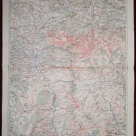
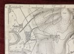
Paracin Topographic Map WWI Military Campaign Serbia
| Type | Military Topographic |
|---|---|
| Material | Paper |
| Original/Licensed Reprint | Original |
| Printing Technique | Lithography |
| City | Paraćin |
$70.00
In stock
WWI Map Paraćin
***
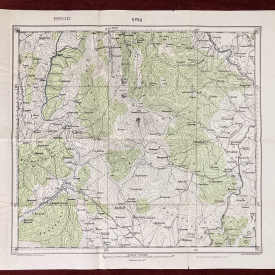
Scale: 1:75,000
Region: Serbia (specifically Paraćin and surrounding area)
Date of Base Survey: 1875
Updated/Published: Marked “Nachtr. 20. II. 1907” (possibly meaning updated February 20, 1907)
Produced by: Austro-Hungarian military
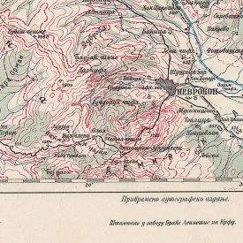
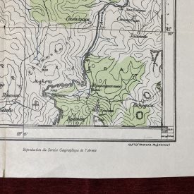
The map centers around the town of Paraćin, located in central Serbia. Other key locations visible include: Ćuprija (northwest of Paraćin), Jagodina (further northwest), Morava River (meandering through the area) and multiple mountain ranges and valleys detailed with contour lines.
Paraćin was part of a strategically significant corridor in Serbia, especially during the Balkan Wars and World War I, as powers sought control over the Morava Valley – a vital transportation and communication route. This map would have supported operational planning and reconnaissance for troop movements, supply logistics, and artillery placement. Consistent with Austro-Hungarian Spezialkarte series used for military planning.
***
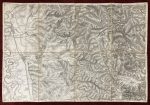
Size: 55 x 38cm
Condition: In very good condition.
***
The item will be shipped in a cardboard tube.
Please see the photos for other details of the item’s condition. More photos are available on demand. If you have any questions, feel free to contact us.
This is an original antique print. We don’t sell reproductions.
Payment
Payment processing options:
- Credit/Debit Card
- Paypal
- Bank transfers - SEPA (€), ACH (us$), BACS (£)-
- Credit/Debit card
- Cryptocurrencies
- AliPay
- WeChat Pay
We kindly ask our buyers to pay within three working days. In case you are having issues with payment, please contact us to let us know.
All invoices are sent electronically, we can also provide physical copies upon request.
Shipping
Shipping method:
All items are shipped via registered priority airmail. In other words, you will receive a tracking number with whom you can trace the book’s location at any given time. In case you want another carrier like UPS, DHL or other, please notify before payment.
Packaging:
Books - shipped in reinforced cardboard packages and plastic foil to protect the package from moisture damage.
Posters, maps, prints, drawings and similar - strong cardboard tubes.
Everything else - unless otherwise specified, items will be sent in envelopes reinforced on one side with cardboard and foil.
Combined Shipping:
It is possible to combine purchases. Since we don’t charge shipping for books, you don’t need to make request a separate invoice.
Please note: If you have ordered more than one item from a different category, please wait for the combined shipping invoice.
Shipping time:
We send all items within 24h of received payment received on a working day. In case we are on holidays (state, religious, personal or other) the item will be shipped the first next working day.
Post offices sometimes need up to 48h to process the tracking number. Usually all tracking numbers will be visible by then.
Delivery time:
Please note, delays due to customs office inspections are not included in the estimate.
Europe(incl Russia): 5-20 days.
North America: 15-30 days.
USA: 20-50 days.
South & Central America: 15-45 days.
Australia & Oceania: 20-50 days.
Africa: 15-40 days.
Customs office:
You may be charged by the customs office in your country. There are no hidden expenses like sales or export taxes unless specified in the item’s description. Please familiarize with the import laws of your country before purchase in case you are not entirely sure if an item subject to customs taxes. For some items an export license is needed and additional fees and time to get the export permit will be clearly stated in the item description.
Some items may end up at customs inspections on departure so we will kindly ask you to be patient while such inspections take place because they can cause a delay in the delivery time.
Also there is a possibility that some item may end at customs inspection in your country. Sometimes it’s a lengthy process, especially for buyers from the US, Italy, France and Brazil.
Returns and refunds
In case you would like to return/exchange the item for any reason you are free to do so. We ask all our buyers to contact us prior to sending an item back. The moment the item arrives back the buyer will be entitled to a refund minus the expenses for shipping and a 15% restocking fee.
Exchange for another item from the store is also an option. It is possible to return an item within 30 days from the date of arrival.
Feel free to contact us if you have any additional questions, we will be happy to answer them!