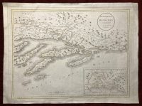
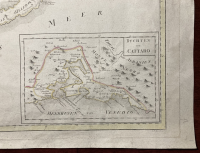
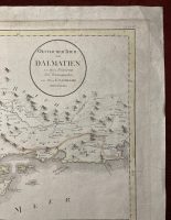

Oestlicher Theil von Dalmatien von P. Santini ; neu herausgegeben von F. [Franz] A. [Anton] Schraembel
Antique map of Dalmatian coast and island in the Adriatic sea. Inset map of the Gulf of Venice and Bay of Kotor in the bottom right corner. Part of the Ottoman empire (Herzegovina) is indicated in the north. Highly detailed and accurate map with pictorially shown relief. Title cartouche in the top right corner. Very scarce hand colored map engraved by Italian cartographer Paolo Santini and published by Franz Schraembel in Vienna.
***
Dimensions: 620 x 470 mm; 24 x 19 inches (approx)
Year: 1789
Engraver: Paolo Santini
Technique: Copperplate
Condition: Minor imperfections, a sign of paper restoration on the back. In very good condition.
***
Item will be shipped in a cardboard tube.
For other details and item condition, please see the photos. More photos available on demand. If you have any questions, feel free to contact us.
This is an original antique map. We don’t sell reproductions.