Antique Map of Italy
***
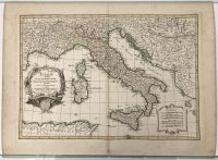
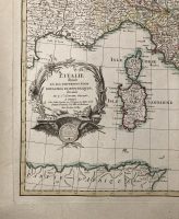
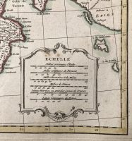
A beautiful old map of Italy drawn by le Sieur Janvier c. 1783 for issue as plate no. 10 in Jean Lattre’s 1783 issue of the Atlas Moderne. It covers the Gulf of Lyon, Corsica, Sardinia, Italy, and the Adriatic Sea, with parts of Hungary and Turkey in Europe, and Africa. The map features an ornamental title cartouche in the lower left indicating the map title, cartographer’s name, place of production, and royal privilege. The lower right features a second cartouche with a six-distance scale.
***
Dimensions: 52 x 39 cm (page) / 20,5 x 15,35 inch; 44 x 31 cm (map) /17,3 x 12,2 inch
Year: 1783
Engraver: Sr. Jean Janvier
Publisher: Jean Lattré
Place Of Publication: Paris, France
Technique: Copperplate
Condition: Centrefold line as issued, 5cm split on fold line in the lower margin, tearing (1cm) on the lower-left edge, some browning and handling marks on edges.
***
The item will be shipped in a cardboard tube.
Please see the photos for other details of the item’s condition. More photos are available on demand. If you have any questions, feel free to contact us.
This is an original antique map. We don’t sell reproductions.