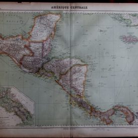
Antique Map Antilles Caribbean Americas Hachette Atlas Universel Antique Map Antilles Americas
***
Dimensions: 675 x 555 mm; 26.5 x 21 inches (approx)
Scale: 1 : 560,000
Year: 1930
Author: Viven St Martin
Engraver: E. Delaune
***
Antique map of Antilles archipelago from the “Atlas Universel de Geographie” by L. St Vivien. Atlas is published in Paris, in 1930. In French language. Map is litographed and in full color with tinted state boundaries. Map also contains two inset maps of islands Guadeloupe and Martinique. The relief is shown by shading and hachures.
***
Condition: Folded as issued, few minor tears and imperfections.
***
For other details and condition see the scans. If you have any questions, feel free to contact us.
***
This is an original antique map. We don’t sell reproductions.
Item will be shipped in cardboard tube.