

New York City Plan Map Antique Engraving 1838 USA
| Original/Reproduction | Original Print |
|---|---|
| Listed By | Dealer or Reseller |
| Date of Creation | 1800-1850 |
| Print Type | Steel Engraving |
| Size | Small (up to 12in.) |
| Height (Inches) | 8 |
| Width (Inches) | 10 |
| Subject | Cityscape |
| Print Surface | Paper |
| Country of Manufacture | France |
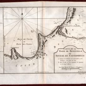
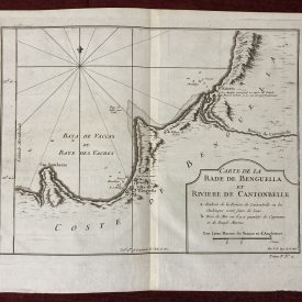
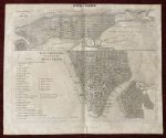
Antique Map of New York
***
Scarce pair of New York City plans.
The upper map, titled Plan Général de la Ville, offers a broad view from the southern tip of Manhattan northward to Westchester County. It features the street grid (including projected developments), major buildings and public squares, as well as prominent military sites such as Fort Washington and Fort George. Portions of Brooklyn and the surrounding rivers are also visible, along with a few early roads extending into Westchester.
The lower map, Plan Particulier de la Partie Sud de la Ville, focuses on Lower Manhattan, stretching north to Washington Place and including a detailed inset of Brooklyn. A comprehensive key identifies 37 important landmarks including churches, colleges, armories, ferry terminals, marketplaces, and civic institutions—offering a valuable snapshot of the city’s infrastructure at the time.
***
Dimensions: 28 x 23; 10 x 8 inches
Year: 1838
Technique: Steel engraving
Published by Jules Renouard in Paris.
***
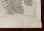
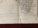
Condition: Folded, signs of aging, crepe tape on the verso, 2cm tear on the lower left edge. Very good overall
***
For details of the item’s condition please refer to the images. If you have any questions, don’t hesitate to contact us!
Payment
Payment processing options:
- Credit/Debit Card
- Paypal
- Bank transfers - SEPA (€), ACH (us$), BACS (£)-
- Credit/Debit card
- Cryptocurrencies
- AliPay
- WeChat Pay
We kindly ask our buyers to pay within three working days. In case you are having issues with payment, please contact us to let us know.
All invoices are sent electronically, we can also provide physical copies upon request.
Shipping
Shipping method:
All items are shipped via registered priority airmail. In other words, you will receive a tracking number with whom you can trace the book’s location at any given time. In case you want another carrier like UPS, DHL or other, please notify before payment.
Packaging:
Books - shipped in reinforced cardboard packages and plastic foil to protect the package from moisture damage.
Posters, maps, prints, drawings and similar - strong cardboard tubes.
Everything else - unless otherwise specified, items will be sent in envelopes reinforced on one side with cardboard and foil.
Combined Shipping:
It is possible to combine purchases. Since we don’t charge shipping for books, you don’t need to make request a separate invoice.
Please note: If you have ordered more than one item from a different category, please wait for the combined shipping invoice.
Shipping time:
We send all items within 24h of received payment received on a working day. In case we are on holidays (state, religious, personal or other) the item will be shipped the first next working day.
Post offices sometimes need up to 48h to process the tracking number. Usually all tracking numbers will be visible by then.
Delivery time:
Please note, delays due to customs office inspections are not included in the estimate.
Europe(incl Russia): 5-20 days.
North America: 15-30 days.
USA: 20-50 days.
South & Central America: 15-45 days.
Australia & Oceania: 20-50 days.
Africa: 15-40 days.
Customs office:
You may be charged by the customs office in your country. There are no hidden expenses like sales or export taxes unless specified in the item’s description. Please familiarize with the import laws of your country before purchase in case you are not entirely sure if an item subject to customs taxes. For some items an export license is needed and additional fees and time to get the export permit will be clearly stated in the item description.
Some items may end up at customs inspections on departure so we will kindly ask you to be patient while such inspections take place because they can cause a delay in the delivery time.
Also there is a possibility that some item may end at customs inspection in your country. Sometimes it’s a lengthy process, especially for buyers from the US, Italy, France and Brazil.
Returns and refunds
In case you would like to return/exchange the item for any reason you are free to do so. We ask all our buyers to contact us prior to sending an item back. The moment the item arrives back the buyer will be entitled to a refund minus the expenses for shipping and a 15% restocking fee.
Exchange for another item from the store is also an option. It is possible to return an item within 30 days from the date of arrival.
Feel free to contact us if you have any additional questions, we will be happy to answer them!